
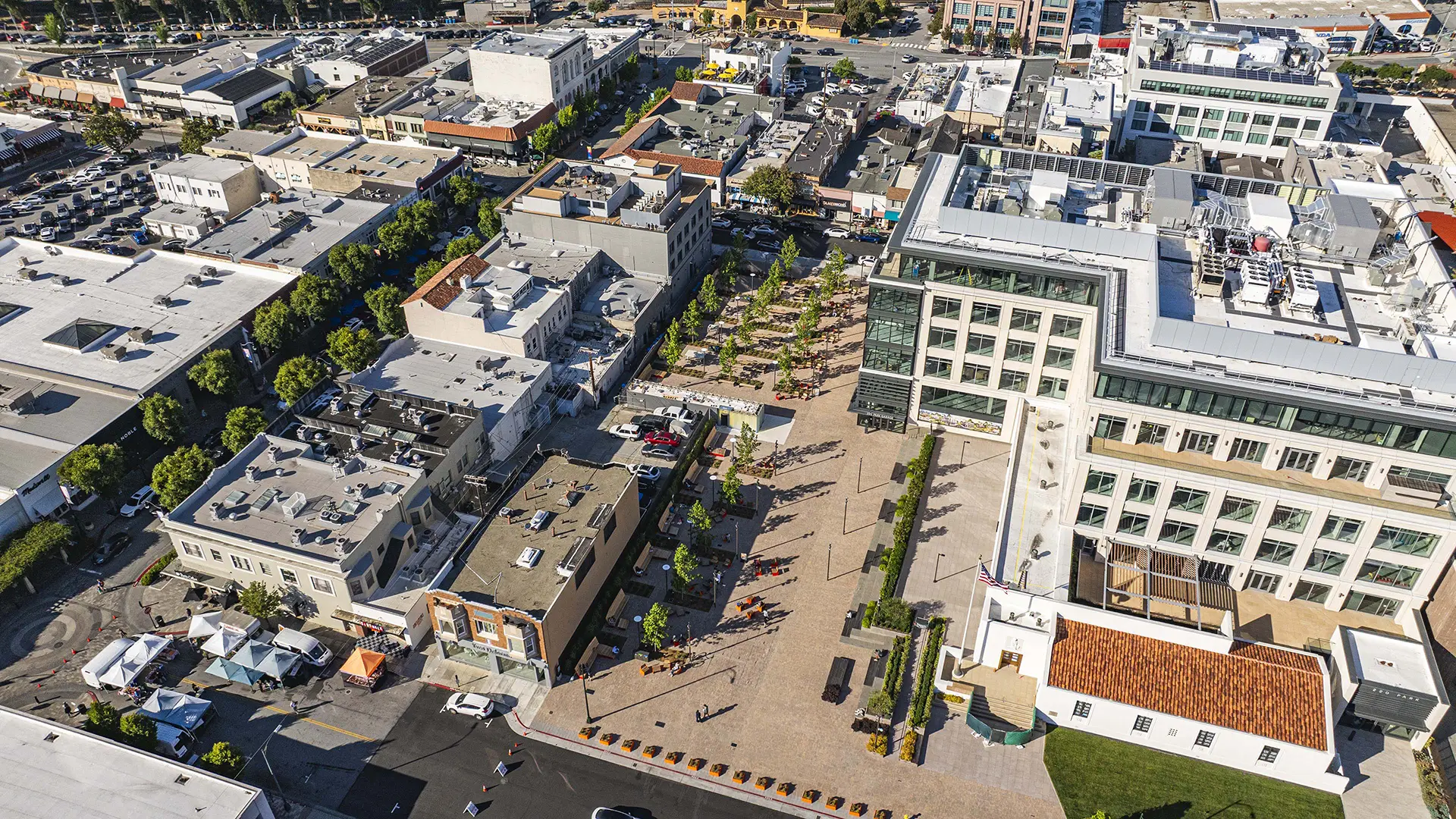


Since its founding in the early 1900s, Burlingame lacked a signature downtown open space. In 2009, the mayor and council kicked off an initiative to make downtown more pedestrian-friendly, including enhancing the Burlingame Avenue retail main street. The capstone of that initiative is the transformation of a one-acre parking lot between Park Road and Lorton Avenue into an outdoor living room—opening in 2026 as Burlingame Town Square.
Organized into two distinct zones, the Town Square is overlaid with a grid of deciduous trees, seating clusters, and large custom wood slat benches along the sunny northwest edge. The Park Road half of the Square includes flexible space and a small performance area to host markets and festivals, while the Lorton Avenue half features communal tables and outdoor games. Flanking curbs are designated for drop-off, supporting the Square as a natural meeting and socializing spot downtown.
Midway through the Square, a water feature clad with angled panels of cast dichroic glass shifts from icy white to aqua, gold, and royal blue depending on sun angle and viewing position, screening a public restroom. Throughout, the design features a warm modern design vocabulary with a palette of oranges, reds, and rusts recalling the brick façades and outdoor dining along Burlingame Avenue. After dark, theater-grade projectors wash the Square’s main walk with a shimmering light artwork evoking Burlingame Creek, now culverted below ground.
Through a partnership between the City and developer of 220 Park, an adjacent six-story office building with ground-level retail and an adaptive reuse of a 1941 Art Deco post office, the Square extends beyond the City’s parcel into this development with additional paving, seating terraces, and an elevated dining area and restaurant. Over time, other surrounding buildings are anticipated to open up to the Square, completing its function as a defining civic gathering space for Burlingame.
Brackenridge Park
At the confluence of the San Antonio River lies Brackenridge Park, a once postcard-worthy destination with a rich heritage obscured by years of neglect.
Reimagining cultural landscapes requires balancing historic preservation, ecological health, and visitor experience. Rather than opting for piecemeal rehabilitation as originally proposed by the city, S...
Pacific Plaza
The latest step in the renaissance of Downtown Dallas has arrived with Pacific Plaza, a 3.89-acre public park that serves the central business district’s burgeoning population and contributes substantially to the city’s outdoor experience. The first of an ambitious four-park initiative, Pacific Plaza complements adjacent urban greenspace with a varied program ...
Norton Rose Fulbright Tower
Standing 28 stories tall, Norton Rose Fulbright Tower integrates the nearby park’s essence into its design, blending the natural landscape with the office tower.
The design connects indoor and outdoor spaces by extending interior lobby finishes into the public realm and flowing exterior planting into ground-floor retail areas, strengthening the li...
The Memorial at Harvey Milk Plaza
Harvey Milk Plaza is located in the heart of San Francisco’s Castro Neighborhood, and hosts one of the city’s busiest transit hubs. The plaza has been the site of countless gatherings and protests, including a candlelight vigil the night of Harvey’s untimely death and the White Night riots, which were sparked by the leniency of the sentence handed down to his ...